Thursday 29 May 2014

Who's calling?


Cuc™ Koo™

Watching BBC Springwatch and the adventures of Chris the Cuckoo reminded of a thought I’d had while at Rannerdale the other week. I had planned to climb up Rannerdale Knotts but changed my mind due to a hail storm so stopped to take photos.


At Rannerdale there is a Cuckoo which I assumed was residential but as I usually only visit that area in May for the Rannerdale bluebells, hadn’t really thought about them being migratory. So I wondered where they normally migrated to and whether this was the same chap/chapess? how can you tell, I haven’t really heard a more manly coo over any other. Which leads me to my question...

Since getting back into nature, regularly visiting RSPB Leighton Moss and Cumbria Wildlife Trust sites I’ve learned a lot and wondered a lot more. Which bird calls are actually two calls, male to female? I have been told for example that when you hear an owl ‘twit-twooing’ it’s actually two owls, male and female calling each other.


Owl A: Twit
Owl B: oi, who you calling a twit?

Are owls the only species to have trade-marked their own word,  Twit™ Twoo™?  I’m guessing the Twit is the male ;-) So are there any other bird species that do the same? When you hear a ‘cuc-koo’ are you hearing the male first and then the female separately or do both have legal rights to use ‘cuc’ and ‘koo’ together?

Beaver: Are you sure they shouldn't be using © or ® instead?

FellRambler: No idea...


Wednesday 28 May 2014

Catbells the first of many fells - Part 2

Knott Rigg-Ard Knots-(Rigg Screes)-Catbells-Maiden Moor-(Nitting Haws)-High Spy-Dale Head-Hindscarth-Robinson-(Buttermere Moss)-(High Snockrigg)-(Moss Force)

12.7miles


After admiring the view of Derwent from Catbells for some time it was time to get going on the main route back. The first of the peaks was Maiden Moor. The summit is wide and flat I took the path along the far edge giving me views of Hindscarth and the valley below. In the distance a Kestrel hovered and dived as three meadow pipits flew off in different directions.

Hindscarth

Kestrel hovering for a taste of Pipit

These walks are more about exploring rather than straight to the summit cairn so before I reached it I investigated many of the interesting crags, Eel crags.

Eel crags

Looking straight down to the valley floor

Another crag Nitting Haws was great and maybe the reason why it’s called High Spy. It’s a fab resting spot to take in the Derwent views and spy down on the hotels below. At the High Spy cairn I can see why Beth and her cousin stopped where they did. The decent and ascent was the biggest in the walk, it looked pretty big from a distance but the more I descended the bigger the ascent looked.


Nitting Haws looking down over Derwent 


As I began the decent I noticed some unusual gold mushrooms glinting in the sun (all mushrooms are fungi but not all fungi are mushrooms I believe) not sure what there are, Google brings up some 'interesting' results, any ideas?

Gold mushrooms
Haven't found out what they are yet


I past Dalehead tarn and began my ascent up Dale Head. Getting great views back down the valley and from the other side Honister pass came into view, it was a little windier this side but luckily the sun continued to shine and held the clouds at bay.


Newlands Beck meanders down the valley

Looking back at High Spy


Honister Pass


Skiddaw from Hindscarth

The summit of Hindscarth protrudes out into the valley and its worth going right out to the furthest shelter. The wind began to pick up as the sun started to lose its strength as the early evening set in. Just one more peak and another descent and ascent to Robinson. That guy was right there is quite an altitude change when you get closer, the gradient doesn't look as steep on the map. 

Wheatear


Buttermere


By the time I got to Robinson the clouds began to drop, swirling around the summits. Luckily no rain.


Crummock Water with Loweswater in the distance


Dropping down to the plateau of Buttermere moss the paths disappeared into bog. My boots are suffering at the moment (have I mentioned that already?) anyway they like drinking water. At least it was at the end of the walk and not the start. Meandering around to find something a little more solid, I thought I’d take a slight detour and peak over the lump of High Snockrigg and the Buttermere lake and hotels below. Here a large group of walkers off for an evening hike to Rannerdale Knots gathered around someone in a red tail-coat as he pointed in various directions with his walking cane before he headed back down.

The path re-emerged and dropped sharply down to the car park. I can’t resist a waterfall so a short walk back up to the base of Moss Force for a few photos.

Moss Force waterfall


Friday 23 May 2014

Catbells the first of many fells

Knott Rigg-Ard Knots-(Rigg Screes)-Catbells-Maiden Moor-(Nitting Haws)-High Spy-Dale Head-Hindscarth-Robinson-(Buttermere Moss)-(High Snockrigg)-(Moss Force)

12.7miles

Part 1 Knott Rigg to Catbells

Weather forecasts are annoying, not going to rain but rains, going to rain but doesn’t. This time it was the latter so I took my chances later in the morning. From past experience anything over Honister pass seems to have a different weather system but I headed off to do more of the Buttermere fells anyway. As it depends on the number of visitors it can take a couple of hours to get there so it was quite a mad idea but armed with a number of routes planned gave me options depending on the time and weather.

After a lovely but rather slow drive up I arrived at my destination at midday managing to squeeze into a spot. All the more reason to start walking at 8am. (rant self edited ;-) )

The clouds were dark but the sun was burning through and I was half expecting thundery showers. I decided it would be ok and went for the full hike, 12 miles, 8 peaks. Starting at Moss Foss waterfall car park I headed straight up Knott Rigg and along to Ard Knots. It was a lovely ridge as I began baking in the sun. Here I got a really good look at the Catbells ridge route all the way round to Robinson, all of it was in black cloud. Don’t look at the black cloud look around the black cloud...

Hindscarth and Robinson from Knott Rigg


Dropping down the sharp yet easy path of Rigg Screes in the brilliant sun I did have a sigh of happiness as the birds tweeted, the lambs played and the cows mooed, just don’t look at the black clouds. Reaching the next field gate I detected mild peril as I caught a bull's attention (I don’t know if it was a bull or whether it would charge just that it had big horns) and with an evil glare raised its nostrils with each menacing moo. The mother and calves were safe over the adjacent wall but why was the mean looking creature in where walkers go through? It moved towards me, averting gaze I kept my head down and walked casually in the opposite direction. It followed. I distracted it by weaving through some trees and carried out the ‘predator confusion effect’ getting as many sheep between us, safety in numbers right? Like watching a Buzzard trying to get lucky in a starling murmuration.

Looking across to Catbells
Dale Head Hindscarth and Robinson

Once at the valley floor I took the road towards Little Town at the foot of Catbells. This time I opted for the more direct back route past the quarry rather than the long steady ridge and as I began climbing the menacing clouds with evil intent dissapated by the heat of the sun. This is a much better route because of the immediate surprise you get when you reach the summit. It was popular as usual , one doing a 360 with their map and an Ooo let’s go over there excitement. And as he said to me they’re much bigger when you get close to them, I did have a Father Ted “these are small, those are far away” smile.

Derwent Water with Blencathra in the distance

Looking across to Skiddaw


But you can only agree with their excitement and understand why it’s most people’s first fell, the first of many.

I fear I may have gone on a bit so until part 2 here is CumbrianRambler and her cousin on her first hike.


Monday 19 May 2014

Gowbarrow and the Mell Fells

Gowbarrow Fell-Little Mell Fell-Great Mell Fell

10.6miles

But it’s only three little hills, most of the walking is getting to each one via single track roads and it’s only a 10miles circular route (not that she believed me). Okay I admit it, it felt a lot longer. I think it was the weather, warm, close and showery and I was feeling very over-encumbered.

Starting at the car park above Aira force the first fell, Gowbarrow fell, rises up in front of you where nestled in the wooded glade below is Aira force. The sun dappled woodland paths around the waterfalls and beck are very lovely.


Aira Force


We took the footbridge across the beck and straight up the fell where you get a great view down the south half of the lake. If you start from the NT car park and take the main front path you get much clearer views and are better than from the summit itself. Most of Gowbarrow fell is covered in heath and is boggy in places. And then it happened. With a miss-guided step one foot squelched deep into bog, great a mud filled boot so early on, not a good thing to happen.

Gowbarrow Fell looking north up Ullswater

To the north the mounds of Little Mell and Great Mell lay waiting.

We dropped down to the forest below for lunch. Forest walks are great for when it’s raining as they really shelter you, Shame there’s none too many in the fells, I’m going to need them. The warmth kept pockets of mist low in the forest making it quite ethereal. Because it was sunny and warm I didn’t bring my waterproof trousers but Beth did and as there’s no “we” in team but rather “I” as in I’ve got waterproofs you’re on your own mate. Great...Luckily my trousers really are super fast drying.


The path up the grassy and windy fell was easy to spot and from the top views over the north end of Ullswater and to the west Great Mell Fell. 

From Little Mell looking at Great Mell with Blencathra behind
Even though there is well trodden path towards Great Mell, this seemed to lean you towards farmers fences with no access through. I thought this may be tricky as no paths are marked on the map so dropped south around the fell to a footpath previously spotted that lead off to Brownrigg farm.

After hiding in a barn to escape another downpour we followed the well signposted way to navigate you through farm to farm we arrived at the base of Great Mell. Again strangely this fell also doesn’t have any paths marked on the OS map but are clearly visible.


Looking back at Little Mell

With the third downpour we very nearly gave up on Great Mell Fell but we were glad we didn’t as it stopped very soon after and the sun shone again. It’s a much more interesting fell with old and unusual looking fur trees though as the glow of the evening sun came down it did light up a patch of gorse on the lower sides of Little Mell.


A great view to Blencathra

Great Mell Fell is indeed a great fell on its own, all for the fabulous views of Blencathra.

From here we took the road back down to the car, luckily the road is small and quiet as it wonders around the farms. Looking back you can see Little Mell and Great Mell.

Great Mell Fell and Little Mell Fell


Soon we arrived at a way marked path to Aira force which followed around the foot of Gowbarrow. You get a really great perspective of Stoney Cove's curve. 

Stoney Cove Pike

A little down the path we met these rather cute playful things and even inquisitively came up to me before scampering off.


A right pair of mischievous Herdy lambs


14 done 200 to go!


Thursday 8 May 2014

Coniston Grumpy Old Man

(Brown Pike)-(Buck Pike)-Dow Crag-Coniston Old Man-Brim fell / (Raven Tor)-Swirl How-Great Carrs-Grey Friar-(Black Sails)-Wetherlam-(Above Beck Fells)
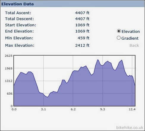
12.8miles


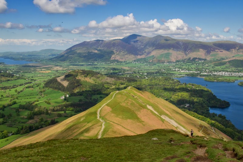
The Old Man with his head in the clouds

Due to rain forecast for midday I chose a fell nearer to home, Coniston Old Man.  Maybe not a good choice on a bank holiday Monday but because of cloud it wasn’t overly crowded.  As the A590 crests over a hill, the fells open out in front of you, it’s a great sight to see every time we drive it. Directly in front of you, you will see Coniston Old Man. Well sometimes...

When you can’t see your destination fell do you abort your walk and go elsewhere? Would make sense if you want a view but if there’s cloud here, there’s probably cloud there too.  And as a photographer said to me on the way up, you’ve just got to go for it. Unfortunately it wasn’t an inversion, it was just cloud and haze.

Arriving at Walna Scar road I made my way along past the paths that leads up behind the Old Man and started my ascent up Brown Pike and Buck Pike. There I watched the old bloke and wondered if the cloud would clear. Every so often it would, giving me a brief flash of his summit.


Path leading to Brown Pike
Bikers coming up Walna Scar side. Walking's cheating right? ;-)


Looking back at the busy Old Man cairn from Raven Tor

Dow Crag from Buck Pike
Dow Crag my next peak, the crags are steep down to Goat’s water but it looks like there’s a path that would make a challenging route up. Maybe next time.

Fun route up maybe?

Goat's Water & C.O.M from Dow Crag


I made my way to the busy summit and admired the hazy views, doesn’t make for good photos though. So I will reserve the right to add photos from other hikes on occasion. 
  
Luckily the weather was mild and the ridge was windless.  Making my way along the ridge I took a detour to get Brim Fell. It’s bit of a drop and oh... as I write this I only just realise it’s the ridge cairn (796m) and not where Brim Fell is mentioned on the map. Oh well!  As it turns out Brim Fell/Raven Tor is a nice detour as it juts out giving you a great view of the Old Man, Levers water and Swirl How.

The Old Man and Low Water from Brim Fell 

Leavers Water from Raven Tor


Memorial to crashed bomber
Taking the path left from Swirl How towards Great Carrs the wind really began to pick up. I’ve lost my beanie hat but with the strong gusts I was happy I had my woolly hat albeit a bit too hot. Here there is a monument dedicated to the Halifax LL505 bomber that crashed here in 1944 after getting lost in cloud during a night navigation exercise.  

Taking the gentle slope down west leads you up to a lone peak, Grey Friar. Here you get views back to Dow Crag and the Old Man and further west another lone fell, Harter Fell. Man it was windy here, luckily there are some large crags facing north you can hide behind. Time for refreshments.

Taking the centre path back up to Swirl How and this time looking east you can see your options. The path drops down the curiously name Prison Band to Swirl Hause beck. I’ve noticed a number of ‘prisons’ here. Were some of these slate and copper mines used as prisons or more likely I can imagine working in them they felt like it, thusly name so by the local workers. 

Here you have the choice to exit and take the beck path down the valley through the mines to Coniston. But why would you, Wetherlam is right there!

Great Carrs from Swirl How

Looking down Tiberthwaite valley

From Swirl How looking at Wetherlam


As a family took the route down I paused as it started to spit. It'll be fine...A short climb and you’re there. A pause to admire the 360 views you can look back along the ridge you’ve just hiked along and to the north, Crinkle Crags, Langdale Pikes and Pike of Plisco. From here you can see your car ( it will be around 2 miles away), I chose the path that kept to the left of the ridge and down over Lower Hows and Above Beck Fells. 

This is where I decided to go a little off piste. Rather than continue the path all the way down Hole Rake and have to come back up again I cut across above the mines. Carefully traversing the crags (I think it would have been quicker to stick to the path) I entered the Coppermines. I do find disused industry quite haunting and intriguing, the way rusted pipes, wires and pulleys are still there. 

After bounding over the moorland and surprising the same family it was little hop over Kennel Crag and around Grey Crag to Low Water beck and on the home straight. 

Another pleasant 13mile hike along ridges and around crags. 


Where to next?..