Knott Rigg-Ard Knots-(Rigg Screes)-Catbells-Maiden Moor-(Nitting Haws)-High Spy-Dale Head-Hindscarth-Robinson-(Buttermere Moss)-(High
Snockrigg)-(Moss Force)
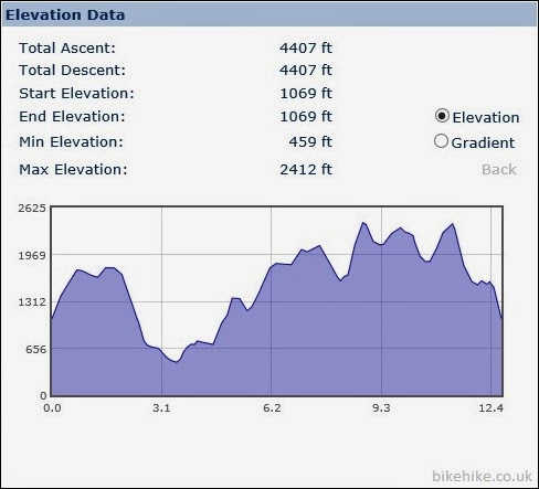
12.7miles
After admiring the view of Derwent from Catbells for some time it was time to get
going on the main route back. The first of the peaks was Maiden Moor. The
summit is wide and flat I took the path along the far edge
giving me views of Hindscarth and the valley below. In the distance a Kestrel
hovered and dived as three meadow pipits flew off in different directions.
 |
| Hindscarth |
 |
| Kestrel hovering for a taste of Pipit |
These walks are more about exploring rather than straight
to the summit cairn so before I reached it I investigated many of the
interesting crags, Eel crags.
 |
| Eel crags |
 |
| Looking straight down to the valley floor |
Another
crag Nitting Haws was great and maybe the reason why it’s called High Spy. It’s
a fab resting spot to take in the Derwent views and spy down on the
hotels below. At the High Spy cairn I can see why Beth and her
cousin stopped where they did. The decent and ascent was the biggest in the
walk, it looked pretty big from a distance but the more I descended the bigger
the ascent looked.
 |
| Nitting Haws looking down over Derwent |
As I began the decent I noticed some unusual gold mushrooms glinting
in the sun (all mushrooms are fungi but not all fungi are mushrooms I believe) not sure what there are, Google brings up some 'interesting' results, any ideas?
 |
| Gold mushrooms |
 |
| Haven't found out what they are yet |
I past Dalehead tarn and began my ascent up Dale Head.
Getting great views back down the valley and from the other side Honister pass
came into view, it was a little windier this side but luckily the sun continued
to shine and held the clouds at bay.
 |
| Newlands Beck meanders down the valley |
 |
| Looking back at High Spy |
 |
| Honister Pass |
 |
| Skiddaw from Hindscarth |
The summit of Hindscarth protrudes out into the valley and
its worth going right out to the furthest shelter. The wind began to pick up as
the sun started to lose its strength as the early evening set in. Just one more
peak and another descent and ascent to Robinson. That guy was right there is
quite an altitude change when you get closer, the gradient doesn't look as
steep on the map.
 |
| Wheatear |
 |
| Buttermere |
By the time I got to Robinson the clouds began to drop, swirling around the summits. Luckily no rain.
 |
| Crummock Water with Loweswater in the distance |
Dropping down to the plateau of
Buttermere moss the paths disappeared into bog. My boots are suffering at the
moment (have I mentioned that already?) anyway they like drinking water. At
least it was at the end of the walk and not the start. Meandering around to
find something a little more solid, I thought I’d take a slight detour and peak
over the lump of High Snockrigg and the Buttermere lake and hotels below. Here
a large group of walkers off for an evening hike to Rannerdale Knots gathered
around someone in a red tail-coat as he pointed in various directions with his
walking cane before he headed back down.
The path re-emerged and dropped sharply down to the car park.
I can’t resist a waterfall so a short walk back up to the base of Moss Force
for a few photos.
 |
| Moss Force waterfall |


Great photos....
ReplyDeleteThanks Mappiman
Delete